Monday, December 13, 2010
Sunday, December 12, 2010
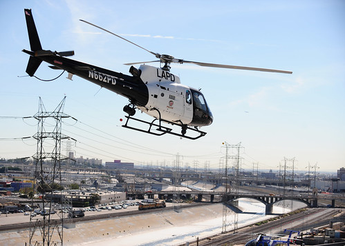
LAPD Air Support AS350

One of LAPD's Air Support Division's newly liveried Eurocopter AS350s passes the Hooper Memorial Heliport - it's the "black and white" of the sky. Photo taken on Nov 4, 2010 by DAVID BERGER / LA Observer / via Flickr
Saturday, December 11, 2010
Saturday, November 13, 2010
TV Helicopter Sky 9 makes Hard Landing @ Whiteman Airpark
Los Angeles' Daily News reported on Nov 12, 2010:
Sister stations KCAL9 and CBS2 report that engine failure forced the hard landing about 8 a.m. Friday at Whiteman Airpark in the Pacoima.
Pilot Derek Bell says that as soon as the Eurocopter's engine began to fail he began autorotation and quickly brought the craft known as Sky 9 back to the airfield.
The helicopter's tail struck the ground and broke off but the craft landed upright on its skids.
image via Daily News server
See more photos after the jump.
See more photos after the jump.
Wednesday, November 10, 2010
Helicopter Raw Video, Missile Launch off of Los Angeles Coast 09-NOV-2010
Video of the November 09, 2010 missile launch from 35 miles off of the Los Angeles coastline.
Video shot by a KCBS/KCAL Cameraman Gil Leyvas from a news helicopter in Los Angeles that shows an object shooting across the sky and leaving a large contrail, or vapor trail, over the Pacific Ocean. Pentagon can't, or wont, Explain 'Missile' Off California Coast.
"Whatever it was, it was spinning up into the sky kind of like a spiral," and was easy to distinguish from condensation trails from jets, he said. "It was quite a sight to see. It was spectacular" said the cameraman.
"Whatever it was, it was spinning up into the sky kind of like a spiral," and was easy to distinguish from condensation trails from jets, he said. "It was quite a sight to see. It was spectacular" said the cameraman.
The FAA has said that no aircraft were in that airspace at the time.
Here's the Fox News report:
Here's the Fox News report:
Saturday, October 16, 2010
Take a tour of a LA Sheriff's Helicopter
Tactical Flight Deputy Clint Hughes of the Los Angeles Sheriff Department's Aero Bureau gives a tour of his patrol operations helicopter, an American Eurocopter AS350B2 "ASTAR", N971SD, one of twelve that the department has.
These Helicopters run 24 hours a day in three hour rotating shifts. The crews fly two 3-hour hops during their 10 hour shifts.
These Helicopters run 24 hours a day in three hour rotating shifts. The crews fly two 3-hour hops during their 10 hour shifts.
Airbus A380 Super Jumbo Jet 1st landing at LAX
From March 19, 2007 via CNBC
Wednesday, October 13, 2010
Saturday, August 14, 2010
Whiteman Airport from above
THE FOLLOWING INFO IS NOT FOR USE IN ACTUAL FLIGHT PLANNING. >
View Larger Map
Whiteman Airport is located in the Pacoima area of the San Fernando Valley in the City of Los Angeles. The Los Angeles County Fire Department Air Operations unit is based at Barton Heliport, a heliport in the southeast corner of this airport. Also, Squadron 35 of the Civil Air Patrol operates from this airport.
Airport Communications
CTAF: 135.0
UNICOM: 122.95
ATIS: 132.1 [0800-2000]
WHITEMAN GROUND: 125.0 [0800-2000]
WHITEMAN TOWER: 135.0 [0800-2000]
SOCAL APPROACH: 120.4(VNY 280-BUR 050) 134.2(VNY 160-VNY 280)
SOCAL DEPARTURE: 120.4(VNY 280-BUR 050) 134.2(VNY 160-VNY 280)
CLASS C IC: 120.4(VNY 280-BUR 050) 134.2(VNY 160-VNY 280)
Tuesday, August 10, 2010
Friday, May 21, 2010
LAPD Air Support operates from Hooper Air
LAPD's Hooper Airport - Listen in on 123.075
View Larger Map
LAPD Hooper Heliport
General Type: Heliport, Status: Operational, Acivation Date: 01/01/1978, Runways: 1, Ownership: Publicly owned, Facility Use: Private, Site Number: 01817.14*H, Location ID: 4CA0, Region: Western-Pacific, District Office: LAX,
Owner City Of Los Angeles, 555 Ramirez St, Space 475, Los Angeles, Ca 90012, 213-485-2011 Manager C.O.-Air Support Div-Lapd, 150 N. Los Angeles Street, Los Angeles, Ca 90012, 213-485-2600
Schedule
Aircraft Helicopters:
Additional Magnetic Variation: 14E (Year 1985), Non-Commercial Landing Fee: No, Wind direction indicator: Yes, Segmented circle airport marker system: No
Remarks Airspace Determination: VFR ONLY.
Runway 1
General ID: 'H1, Length: 205 ft, Width: 105 ft, Runway Surface Type Condition: Portland cement concrete
Read more: http://www.city-data.com/airports/Lapd-Hooper-Heliport-Los-Angeles-California.html#ixzz10Eg02kZ5
View Larger Map
LAPD Hooper Heliport
General Type: Heliport, Status: Operational, Acivation Date: 01/01/1978, Runways: 1, Ownership: Publicly owned, Facility Use: Private, Site Number: 01817.14*H, Location ID: 4CA0, Region: Western-Pacific, District Office: LAX,
Unicom Frequency: 123.075 mHz,
Aeronautical sectional chart: Los Angeles, Tie-In FSS: No, Tie-In FSS ID: HHR,
Tie-In FSS Name: Hawthorne,
Tie-In FSS Toll-Free Number: 1-800-WX-BRIEF,
Elevation: 302 ft, Elevation determination method: Estimated, Air traffic control tower: No, Boundary ARTCC (FAA) computer ID: ZCL, Boundary ARTCC ID: ZLA, Boundary ARTCC Name: Los Angeles, Airspace Determination: Conditional, NOTAM Service: No, Inspection Group: Owner, Inspection Method: 5010-2 Private use mail out program
Location State: California, County: Los Angeles, City: Los Angeles, GPS (Degrees): Lat: 34° 02' 36.044'', Lng: -118° 14' 49.265'', GPS (Seconds): Lat: 34.043346, Lng: -118.247018, GPS determination method: Estimated, Distance from central business district: 1 mi (SW), Find on map >>
Location State: California, County: Los Angeles, City: Los Angeles, GPS (Degrees): Lat: 34° 02' 36.044'', Lng: -118° 14' 49.265'', GPS (Seconds): Lat: 34.043346, Lng: -118.247018, GPS determination method: Estimated, Distance from central business district: 1 mi (SW), Find on map >>
Owner City Of Los Angeles, 555 Ramirez St, Space 475, Los Angeles, Ca 90012, 213-485-2011 Manager C.O.-Air Support Div-Lapd, 150 N. Los Angeles Street, Los Angeles, Ca 90012, 213-485-2600
Schedule
Aircraft Helicopters:
Additional Magnetic Variation: 14E (Year 1985), Non-Commercial Landing Fee: No, Wind direction indicator: Yes, Segmented circle airport marker system: No
Remarks Airspace Determination: VFR ONLY.
Runway 1
General ID: 'H1, Length: 205 ft, Width: 105 ft, Runway Surface Type Condition: Portland cement concrete
Read more: http://www.city-data.com/airports/Lapd-Hooper-Heliport-Los-Angeles-California.html#ixzz10Eg02kZ5
Sunday, May 16, 2010
Friday, May 14, 2010
Thursday, May 13, 2010
Emergency Landing at LAX with ATC audio
American Airlines flight #31 bound for Honolulu made an emergency landing at Los Angeles International Airport August 5, 2008 at 9:30AM Local Time.
All passengers and crew managed to escape safely via the emergency inflatable slides.
Two minor injuries were reported among the seven crew members and 150 passengers on board.
At the same time an Emirates Airbus A380 was in-bound for landing to continue its tour around the world. LAX air traffic control refers to the Emirates A380 as "Emirates Super" in the Live ATC transmission.
Nippon Cargo Boeing 747-400F takes off from LAX
Nippon Cargo Boeing 747-400F departing Los Angeles on a wet runway
Note the jet blast water blow-back and condensation clouds forming on the wings.
Monday, May 3, 2010
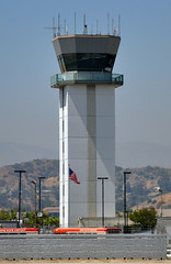
118.700 is where Burbank Tower talks to aircraft.
Burbank Tower
Originally uploaded by sfPhotocraft
Originally uploaded by sfPhotocraft
Put 118.700 mHz into your air radio when you're in the San Fernando Valley to hear the tower at BUR give landing clearance to incoming flights, flights transitioning it's airspace, and take-off clearance to aircraft on the runway. If there's a mountain range between you and the tower, you'll probably only hear one way transmissions from the air.
123.025 mHz is where the helicopters talk
Tune your radio to 123.025 mHz AM to hear the Helicopters over Los Angeles announce their location and altitude. LAPD, LA Sheriff, CHP, LACoFD, LAFD, along with news helicopters can be heard here.
Hello Folks! Got 'Cher Ears On?
THIS IS LAX AIR RADIO,
a publication of facts, points of interest, and myths about the world of the air canopy over Los Angeles.
Published and portions Copyright by HYBRIDPICTURES.com
If you're in the Los Angeles, California area and you have a radio that picks up air traffic frequencies you're in luck because there lots going on up there. If you need a radio, LAX AIR RADIO will recommend some affordable models.
Stay tuned...
Subscribe to:
Comments (Atom)


